[ad_1]
China has a clear interest in the new Kyaukpyu (or Kyaukphyu) deep sea port in Myanmar that would provide a strategic foothold on the Indian Ocean and be connected overland to its underdeveloped southwestern areas. Kyaukpyu is located on India’s eastern shores with Myanmar. There are concerns that China could transform Kyaukpyu into a naval port or a dual-use facility in the Bay of Bengal. Beijing views Kyaukpyu as a viable transport corridor with strategic benefits for China’s Indian Ocean strategy.
Why is the Kyaukpyu port a danger to India?
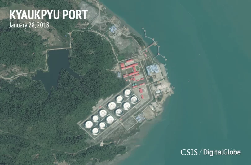
Kyaukpyu port lies on the westernmost tip of Myanmar, along the Bay of Bengal. The 25-meter-deep harbour is being developed as another Belt and Road Initiative (BRI) demonstration project for the mutual benefit of Myanmar and China. The port is part of a Special Economic Zone (SEZ) and the China-Myanmar Economic Corridor (CMEC). When constructed, this will be close to INS Varsha; the Indian Navy Naval base being built in the Bay of Bengal. The base would be constructed along the coast with underground chambers to store India’s nuclear submarines. The distance between the two sites is about 1000 kms.
In 2009, the Chinese corporation CITIC signed early memorandums of understanding (MOUs) for the Kyaukpyu port project and a railway connecting the Special Economic Zone (SEZ) to southern China, predating the renowned Belt and Road Initiative (BRI).

China has been utilising Pakistan to expand its most ambitious project, CPEC (China-Pakistan Economic Corridor), which will be part of BRI, on India’s western side for some time. But CMEC in India’s east requires greater attention as China’s footprint in chaotic Myanmar has increased dramatically since last year’s military coup.
China’s record with dual-use ports in the Indian Ocean is worth questioning. The Chinese-supported port of Gwadar in Pakistan has already provided military services to the Chinese People’s Liberation Army. In Sri Lanka, China has been prohibited from utilising the port of Hambantota for military uses, in which it holds a 70% share.
Kyaukpyu Port’s importance to China
To comprehend China, one must be familiar with ‘China’s Two Oceans Strategy’ and ‘Malacca Dilemma’.
In its basic form, the 2-ocean strategy focuses on facilitating China’s access to the Indian and Pacific oceans to break what China believes to be encirclement of its boundaries.
The Malacca Dilemma involves China’s freedom of movement in the ocean, notably in the Malacca Strait. As China does not have a better route to the Indian Ocean, all Chinese civilian and military ships, including submarines, are compelled to transit through a choke point or restricted sea zone at Malacca.
The United States, Japan, and India established a network of undersea detection systems from the South China Sea to the Andaman Sea to monitor Chinese actions. This network is known as the Sound Surveillance System, or SOSUS. This poses significant challenges to Chinese maritime activities in the region.
The initial plan was to access the Indian Ocean through Pakistan, but Gilgit Baltistan’s hostile terrain, Iran’s influence and the United States’ significant presence in Pakistan and Afghanistan kept the Chinese on edge.
This prompted the Chinese to seek a less risky alternate path. Myanmar, a lawless nation mired in chaos for decades and mostly overlooked by the West, fits the Chinese plan.
Hence, China opted to send BRI through Myanmar and came up with the “jewel in the crown” of the BRI corridor in Kyaukpyu for an estimated $7 billion. In 2013, the Kyaukphyu Special Economic Zone or KP SEZ initiative was announced for the first time. CMEC, similar to Pakistan’s CPEC, is a 1700-kilometre corridor with an inverted y-shape.

Kyaukpyu is the starting point for the Sino-Myanmar pipelines. This satisfies China’s energy requirements. Here, gas-fired power plants with a combined capacity of approximately 300 Megawatts are being constructed, which will be linked to a 1,400-kilometer high-speed Kunming-Muse-Mandalay-Kyaukpyu railroad connecting the KP SEZ with China, creating the shortest and most cost-effective route between China and the Indian Ocean.
According to reports, China reluctantly agreed to numerous requirements from the Myanmar government in 2019. The Chinese President visited Myanmar in January 2020. The meeting occurred only a few weeks before a sudden global pandemic shutdown.
CMEC’s military implications
China’s Navy, the People’s Liberation Army Navy (PLAN), would be able to monitor India in the Bay of Bengal thanks to CMEC. US Naval Intelligence estimates that by 2030, PLAN or the Chinese Navy will have 67 new big ships and 12 new nuclear-powered submarines, sufficient to control the Indian Ocean.
An alarming situation
The Indian government is preparing a variety of countermeasures, including SAGAR. ‘Security and Growth for Everyone in the Region’ is what SAGAR stands for. Since the initial use of the phrase in 2015 at Port Louis, the term has been expanded to encompass additional features, such as ties to the Indo-Pacific area.
SAGAR entails a heightened awareness of the maritime domain. This is carried out using the Integrated Coastal Surveillance System. India has financed installing coastal radar systems in numerous countries bordering the Indian Ocean. Even though SAGAR is a component of India’s official policy, it is not well defined in the open source.
India has been accelerating its efforts to offset China’s movements in the Indian Ocean, but the reality is that India lacks the financial resources to exert influence over all of its neighbours. India’s development projects in Myanmar have slowed since the coup by the military junta, but attempts are being made to keep the junta on India’s side.
[ad_2]
Source link