[ad_1]

In November 2021, the Ethiopian House of People’s Representatives enacted a new proclamation 1263/2021 to re-establish a new institutional arrangement for the Federal Democratic Republic Government of Ethiopia. This new proclamation has merged both the Ethiopian Space Science and Technology Institute (ESSTI) and the Ethiopian Geospatial Information Institute (EGII). This is according to a 10-year strategic plan by the Ethiopian government to operate a competitive space and geospatial program under a central Space Technology and Geospatial Institute (STGI). The new entity, expected to be created in 2022 will become operational with core technical centres and technical directorates that will be established in alignment with national priorities and global trends in the geospatial and space industries.
While the importance and value of the geospatial information and space program have been well recognized by the Government of Ethiopia in the early 1950s. In 1954, the Ethiopian Mapping and Geography Institute was established under the Ministry of Education and Arts to produce fundamental geospatial datasets to support national development agendas. The institute has gone through several restructuring and was renamed several times. In 1998 it was renamed the Ethiopian Mapping Agency (EMA) and migrated to the Ministry of Finance and Cooperation to manage cartographic and digital mapping and remote sensing in the country. In 2018, the agency was renamed the Ethiopian Geospatial Information Institute (EGII) as a way of restructuring. With about 400 employees, EGII engages in aerial photography, photogrammetry, geodetic surveying, spatial data infrastructure among other things for planning, infrastructure monitoring, irrigation, elevation maps, urban planning, structural and regional planning.

According to Dr Tulu Besha Bedada, the Director-General of EGII, the institute has also produced several maps and high-resolution imageries and have capabilities in LiDAR technologies. The EGII has maintained cooperation with many local and international institutions and participating in the Global Monitoring of the Environment and Security and Africa (GMES & Africa) project, and the implementation of the United Nations Integrated Geospatial Information Framework that operated under the purview of the United Nations Global Geospatial Information Management (UN-GGIM).
ESSTI on the other hand is a research, training and space infrastructure development institution established in 2016 to manage the country’s national space program. The main objectives of ESSTI are to enable the country to fully exploit multi-dimensional uses of space science and technologies; to produce demand-based knowledgeable, skilled and attitudinally matured professionals in the field of aerospace science that enable the country to become internationally competitive in the sector; to develop and strengthen space science and technology infrastructures to speed up space science and technology development in the country, and enable the country to be a robust contributor for the development of aerospace science and technology.

According to Dr Yeshurun Alemayehu Adde, the Deputy Director-General of ESSTI, the vision of the new leadership of ESSTI, appointed in September 2020, is to make ESSTI exemplary and one of the best space agencies in Africa. It manages the Entoto Observatory and Research Centre (EORC) and launched both the ETRSS-1 and ET-SMART-RSS satellites in 2019 and 2020 respectively.
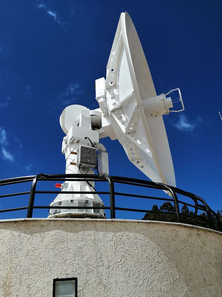
Ethiopia is one of the few East African countries with a space agency (others are Kenya, Rwanda, and Zimbabwe) and the one with the highest number of satellites. It is expected that this merger will further strengthen the nation’s space program and geospatial industry. In May 2021, ESSTI launched a 7.3 metres multi-satellite tracking and data receiving ground station which is receiving high-quality data with resolution up to 0.5meters from the China-Brazil Earth Resources Satellite 4 (CBERS-4), China’s High-definition EO Gaofen 1, Gaofen 3 and Gaofen 5 remote sensing satellites, and the SuperView-1 operated by Beijing Space View Technology. As a short and medium plan, Ethiopia is hoping to construct a satellite manufacturing, assembly and integration testing centre, and a communications satellite, a high-resolution earth observation satellite, as well as advance in the development of the geospatial industry.
In this regard, the newly established Space Technology and Geospatial Institute is expected to bridge the digital divide in this fourth industrial revolution where geospatial and space-derived datasets are recognized as Data Economy needed to ensure sustained and inclusive socio-economic development as well as play key roles to address global challenges such as climate change, pandemics, disasters, terrorism, conflicts, etc. The new restructuring will position Ethiopia on the right track and leverage effective management and utilization of space and geospatial services and products.

The Authority on News, Data and Market Analysis for the African Space Industry.
Click here to get real time data and information on every Segments and players in the African space and satellite industry.
[ad_2]
Source link